
Avionics
Batteries
Books & Videos
Charts
Composite Materials
Covering Supplies
Electrical
ELTs
Engine Parts
Flight Training
Flight Planning
Gifts
GPS
Hardware
Headsets
Instruments
Landing Gear
Metals & Plastics
Pilot Supplies
Radios
Tires & Tubes
Tools
Wood Products
Kits & Plans
FBO Supplies
Liqui Moly AERO
Catalogs

GARMIN GPSMAP 696
GPS_Garmin_GARMIN-GPSMAP-696

Garmin Like other portable Garmin devices, the 696 includes the following enhanced aviation databases: Features What Specifications
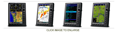
See the Big Picture
GPSMAP 696 Meet our ultimate portable MFD: the GPSMAP 696, an all-in-one navigator designed exclusively for aviation. Featuring a large screen, detailed electronic charts and real-time weather, the 696 is your own personal avionics system.
The GPSMAP 696’s bright 7-inch diagonal high-definition sunlight-readable display makes detailed mapping easy to see day or night — you can even view an entire approach plate on the large-format display. For easy operation, the bezel around the screen includes soft keys and a joystick control. And with a fast 5 Hz GPS update rate, the 696 renders graphics and presents flight data smoothly and continuously.
No Charts? No Problem.
With the addition of Garmin FliteCharts®¹ and IFR map mode, the GPSMAP 696 has Class 1/Class 2 electronic flight bag (EFB) capability, reducing the use of paper charts in the cockpit. With FliteCharts, you can quickly find and view all U.S. NACO departure procedures (DP), standard terminal arrival routes (STARs), approach charts and airport diagrams. If the current approach is known, GPSMAP 696 automatically selects the correct chart based on the flight plan. When in IFR map mode, the 696 can display victor airways, jet routes, minimum enroute altitude and leg distance, much like found on paper enroute charts.
Add Weather and Radio
The GPSMAP 696 includes a GXM 40 smart antenna, which gives you access to high-resolution weather and audio entertainment right in the cockpit (XM subscription required). XM WX™ Satellite Weather includes next generation radar (NEXRAD), aviation routine weather reports (METARs), terminal aerodrome forecasts (TAFs), temporary flight restrictions (TFRs), lightning, winds aloft and more for the U.S. and Canada. In addition, the 696 can receive PIREPs, turbulence forecast and icing forecast information. The weather data can be laid directly over the unit’s navigation and topographic map databases. With 170+ channels of digital music, news and programming through your aircraft headset or cabin audio system, you’ll stay informed and entertained.
Enhance Situational Awareness
The GPSMAP 696 features a high-resolution terrain page showing hazards relative to your altitude and a vertical profile of terrain along your route of flight. It comes with a built-in Jeppesen database, and an Americas, Atlantic or Pacific terrain database. It also includes an obstacles database for the U.S. or Europe. Using this information, the 696 displays your flight route over contour terrain mapping. With information from the terrain and obstacles databases, the 696 monitors your current position in relation to surrounding terrain to provide alerts. You can even customize your own minimum clearance levels to receive terrain cautions. The 696 also comes with a realistic “view from space” satellite imagery basemap.
Receive Altitude-Sensitive Alerts
When in the air, Garmin’s new Smart Airspace™ feature makes it easier than ever to identify what airspace lies ahead. Smart Airspace automatically highlights airspace close to your current altitude and de-emphasizes airspace away from the current altitude, which gives you increased situational awareness.
 | = Available today |
 | = Available in 3-10 days |
 | = Available in 11 days |
") | = Unknown (3 weeks or more) |
 | 11-07049 | Garmin GPSMAP 696 695 Carrying Case | 89.08 EUR | | ||||
| 11-07053 | Garmin GPSMAP 696 695 Ac Adapter 220V | 80.31 EUR | | |||||
 | 11-07057 | Garmin GPSMAP 696 695 Yoke Mount | 129.35 EUR | | ||||
| 11-07059 | Garmin GXM 40 Antenna Flange Mount | 5.50 EUR | | |||||
| 11-07350 | Garmin GPSMAP 696 695 Owners Manual | 122.40 EUR | | |||||
 | 11-07783 | AirGizmos Garmin 696 695 Audio Jack | 20.05 EUR | | ||||
 | 11-08027 | Make It Glare Wizard 696 695 | 49.48 EUR | |


 | Call us at +49 7634 9057700 from 08:00 to 13:00 CET |


