
Avionics
Batteries
Books & Videos
Charts
Composite Materials
Covering Supplies
Electrical
ELTs
Engine Parts
Flight Training
Flight Planning
Gifts
GPS
Hardware
Headsets
Instruments
Landing Gear
Metals & Plastics
Pilot Supplies
Radios
Tires & Tubes
Tools
Wood Products
Kits & Plans
FBO Supplies
Liqui Moly AERO
Catalogs

GARMIN GPSMAP 96/96C
GPS_HANDHELD_Garmin_GARMIN-GPSMAP-96-96C-

The portable GPSMAP® 96, along with the color GPSMAP 96C, integrate full-featured GPS navigation with a Jeppesen database and comprehensive towers-and-obstacles database — giving pilots the freedom to go anywhere. The pilot-friendly GPSMAP 96 has a bright, sunlight-readable, 4-level grayscale display, making map detail easy to read. With 23 megabytes of memory and a mini-USB port, users can quickly download and store map data from a variety of optional MapSource CD-ROMs. Its simple one-thumb keypad control literally puts the world of GPS capability in the palm of your hand. Whether on land, sea, or air, the GPSMAP 96 is the smart, versatile way to get there: Like all of Garmins new aviation portables, the GPSMAP 96 also provides advanced navigation capabilities on the road or water. It features a built-in basemap depicting highways, major roads, lakes, rivers, railroads and state and national borders. It also provides automatic-route generation, off-route recalculation, and turn-by-turn directions with audible tones to alert the driver of upcoming turns. An added bonus: The GPSMAP 96 is not only waterproof, but also floats! Features
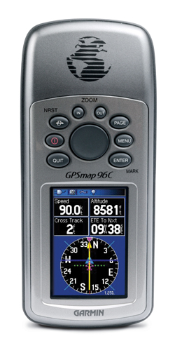 The GPSMAP 96 offers an extensive Jeppesen database along with a U.S. database of obstacles for the ultimate in moving-map situational awareness. It depicts Jeppesen® airport data overlaid on an electronic map, localizer-like runway extensions, a GPS-derived horizontal situation indicator (HSI) and information on nearby airports (including identifier, bearing and distance to each). It also features a detailed database of nearby obstructions like radio towers and high-rise buildings. Using symbology, it depicts an obstacle along the flight route, giving pilots a visual cue and alerting them to potential hazards ahead.
The GPSMAP 96: One nav fits all.
 | = Available today |
 | = Available in 3-10 days |
 | = Available in 11 days |
") | = Unknown (3 weeks or more) |
 | 11-90210 | Garmin Mcx To BNC Plug Adapter 696 695 aera | 42.35 EUR | | ||||
 | 11-90345 | Garmin GPSMAP Power Data Cable 196 96C | 42.67 EUR | | ||||
 | 11-90325 | Garmin GPSMAP Carrying Case 96C 96 | 22.38 EUR | |


 | Call us at +49 7634 9057700 from 08:00 to 13:00 CET |


