
Avionics
Batteries
Books & Videos
Charts
Composite Materials
Covering Supplies
Electrical
ELTs
Engine Parts
Flight Training
Flight Planning
Gifts
GPS
Hardware
Headsets
Instruments
Landing Gear
Metals & Plastics
Pilot Supplies
Radios
Tires & Tubes
Tools
Wood Products
Kits & Plans
FBO Supplies
Liqui Moly AERO
Catalogs

GARMIN GPSMAP 496
GPS_Garmin_GARMIN-GPSMAP-496

Fly smarter and safer with the GPSMAP 496 on board. This “know-it-all” mini-MFD puts more power and information at your fingertips than any other portable handheld in the history of aviation. Similar to the GPSMAP 396, the 496 combines satellite datalink weather with a detailed color map and terrain alerting, then takes it up a notch with even more high-end software and features. The 496 is a “must have” for any pilot. View Your Position on Taxiways Easily Access AOPA Airport Directory Receive Altitude-Sensitive Smart Airspace™ Alerts Navigate with Enhanced Terrain and Aviation Databases Enjoy Faster Update Rate for Maps and Indicators Make Informed Decisions with Optional Weather and Traffic Navigate by Air, Land or Sea Atlantic Data Base 496 does not include XM weather feature. Features
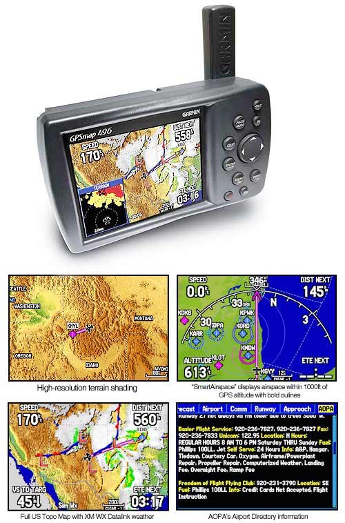
Garmin SafeTaxi™ data providesdetailed taxiway diagrams and position information for over 850 U.S. airports. Preloaded on the unit, this information helps you navigate unfamiliar airports with confidence and shows your aircraft’s exact position on the field.
Look up taxi services, plan an overnight, choose fuel stops and more with the Aircraft Owners and Pilots Association (AOPA) Airport Directory included on the GPSMAP 496. This indispensable reference guide puts a wealth of airport and travel information at your fingertips. It offers detailed information for over 5,300 U.S. airports along with the names and phone numbers of thousands of FBOs, plus ground transportation, lodging, restaurants, local attractions and more.
When in the air, Garmin’s new Smart Airspace feature makes it easier than ever to identify what airspace lies ahead. Smart Airspace automatically highlights airspace close to the pilot’s current altitude and de-emphasizes airspace away from the current altitude, which gives you increased situational awareness.
The GPSMAP 496 features a built-in Jeppesen database with terrain and obstacle databases. Fly with informed confidence thanks to the enhanced, higher-resolution terrain database. With over ten times as much data as the 396’s terrain database, the 496 provides even more visual reference. It monitors your current position in relation to surrounding terrain to provide alerts. Even customize your own minimum clearance levels to receive terrain cautions. With the unit’s Jeppesen® database, you can view your flight route displayed over contour terrain mapping. The addition of private airports and heliports to the database provides even more navigation and emergency "nearest" options.
For added realism and safety, the 496 updates map data and "Panel" page instruments at 5 Hz, a significantly faster update rate that gives you a smoother, near “real-time” presentation of your aircraft’s analog indicators, such as the HSI and turn coordinator.
With an optional subscription to XM WX Satellite Weather™ and the included GXM 30A smart antenna, you’ll have access to constantly-updated, high-resolution weather data for the U.S, right in the cockpit. Weather information includes Next Generation Radar (NEXRAD), Aviation Routine Weather Reports (METARs), Terminal Aerodrome Forecasts (TAFs), Temporary Flight Restrictions (TFRs), Lightning and Winds Aloft, plus more and can be laid directly over the 496’s Jeppesen and topographic map databases. Add a Garmin Mode S transponder, and the 496 will also display TIS traffic alerts that identify surrounding air traffic.
Garmin’s GPSMAP 496 comes ready to go right out of the box with preloaded City Navigator® NT street maps and a hefty points of interest (POIs) database, including motels, restaurants, fuel, ATMs and more. Simply enter a destination, and you’re automatically routed with voice-prompted turn-by-turn directions. In addition, GPSMAP 496 accepts customized points of interest such as school zones and safety cameras and includes proximity alerts to warn you of upcoming POIs. Add optional BlueChart® g2 data cards, and turn the 496 into a color chartplotter.
 | = Available today |
 | = Available in 3-10 days |
 | = Available in 11 days |
") | = Unknown (3 weeks or more) |
 | 11-03509 | AirGizmos Garmin 296 396 495 496 Panel Dock | 156.94 EUR | | ||||
| 11-18863 | Garmin GPSMAP Carrying Case 196 296 396 495 496 | 33.53 EUR | | |||||
 | 11-07939 | Make It Glare Wizard 496 495 | 68.41 EUR | |


 | Call us at +49 7634 9057700 from 08:00 to 13:00 CET |


