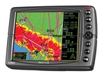
GPS_AvMap_AVMAP-GEOPILOT-II
High Performance, Affordable Price Large display, Safe Navigation Most Accurate Information Enhanced Situational Awareness Multifunctional: Navigate by Sky and Land! One region ( Americas / Europe + Africa / Asia + Australia ) Jeppesen® database with Victor Airways, Marine objects, and private airports. Yes
The GeoPilot II, the new portable navigator developed by AvMap based o the success of the GeoPilot, is high performance and truly affordable. More Hi Quality hardware and Software features have been added: GeoPilot II is faster than ever thanks to the new 300 MHz processor and is more compact and practical with the built-in GPS receiver and richer in information.
AvMap GeoPilot II displays all the information you need on a wide 5” color LCD. The display is sunlight-readable and equipped with a sensor for automatic brightness control. The information is sharp and bright and the map page is fully customizable. The large control buttons and unique toggle cursor control make naviga ting through menus and editing flight plans easy.
The maps preloaded on the SD memory card includes the Jeppesen® navigation database with terrain and vertical obstructions. The Map also includes Victor Airways, marine objects, ULM Aerodromes and private airports. This enhanced database provides more navigation and emergency “nearest” options.
Situational awareness is greatly improved with TAWS (Terrain Awareness Warning System). With the new Crossed Airspace Predictor function, you can get a preview of the airspaces that you will cross along your flight, while the Crossed Airspace Advisor provides warnings during the flight on airspaces being crossed.
AvMap GeoPilot II is engineered for aeronautical as well as terrestrial use as it can fit perfectly in your aircraft and in you car. With the optional 2GB SD Card preloaded with Tele Atlas Maps of all North America or Europe, GeoPilot II converts into an advanced car navigator with turn-by-turn vocal instructions!
Dimensions (mm)
140x100x35.4
Weight
390g
Display
LCD TFT 5" (12,7 cm)
Display brightness
400 nits
Automatic brightness control
Yes + Night Palette for night flying
Display Colors
64 k
Display resolution
320x240 pixels
GPS Receiver
Built-in Sirf Star III 20 channels
Processor
Arm9 300Mhz
RAM
32 MB
Memory Support
Secure Digital (SD) 256 / 512 MB
Power supply
Charger 10/35 V DC
Built-in Speaker
External GPS antenna serial Port
Operating System
AvMap
Software update
Free
2D view
Land Elevation (color coded topographic map showing the altitude of the terrain)
Turn-by-turn vocal instructions
Yes, with built-in speakers (only for terrestrial navigation).
Horizontal or Vertical mode
No
Full flight planning capability
Yes, up to 15 flight plans of up to 100 legs each
Editable aircraft checklist
Yes
Trip computer
Yes
Full nav data Page
Yes
Full simulator functions
Yes
TAWS - Terrain Awareness and Warning System
Yes + Crossed Airspace Predictor and advisor
Integration with other on board navigation systems.
Yes
Full or split HSI / RMI screen with data fields
Yes
Maps preloaded
Low Airways
Yes
Private Airports (for USA)
SD memory card
Flexible holder with suction cup
Quick start guide
External GPS antenna
Antenna cable extension
Yes
AC / DC adaptor
Yes
![]() | = Delivery today |
![]() | = Delivery in 3-10 days |
![]() | = Delivery in 9 days |
![]() | = Unknown (3 weeks or more) |
![]() | 11-06249 | AVMAP GEOPILOT II EUROPEAN DB | 887.32 EUR | ![]() |
![]() | Call us at +49 7634 9057700 from 08:00 to 13:00 CET |